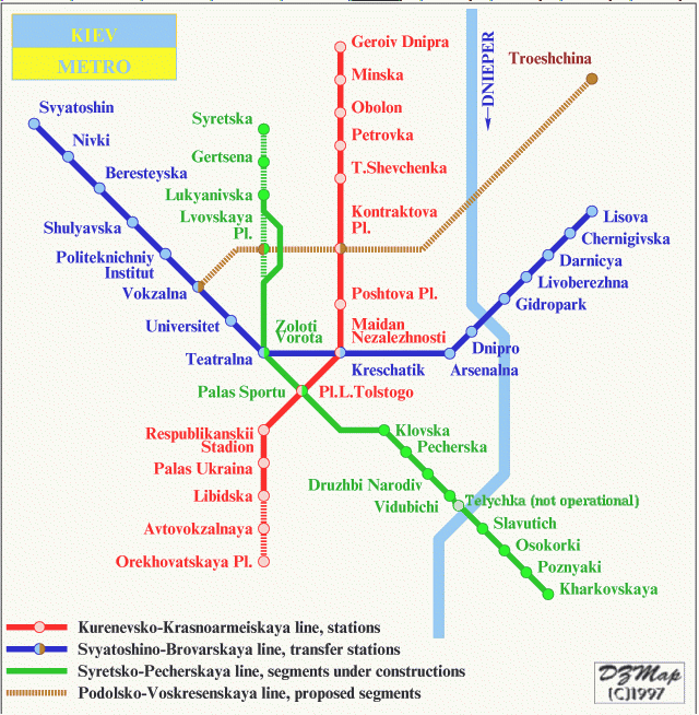
Kiev metro was opened in November, 1960. Kiev metro consists of 3 operating lines (Svyatoshinsko-Brovarskaya, Kurenevsko-Krasnoarmeyskaya, Syretsko-Pecherskaya) and two building lines. Metro works from 6:00 till 24:00 daily. Kiev metro is still the largest in Ukraine. For passengers transportation about 600 coaches are used, and passenger turnover exceeds one and a half million a day.
Kiev metro had a chance to become the second metro railway in Europe after London. In 1884 the technical plan of the railway, connecting the slope below Pochtovaya (Post) square and the area of Bessarabian square, was submitted to the town council. But the plan was turned down and the new opportunity for the building presented itself only in 1916. This time the proposal of the city transport improving was made by the then president of Kiev department of Russian-American Chamber of Commerce.
Building in Kiev was conducted quite scattered and the city was situated at undulating ground in addition, that’s why the movement across the city was difficult especially because of the population growth. Tramways were not able to cope with the increasing passengers steam but expansion of the tram fleet was dangerous. In December, 1916, American Chamber was given an answer, saying that the city council was agree to accept the funds for the metro railway building in Kiev but not on concession terms. The chamber was not satisfied but didn’t decline the plan.
The revolution of 1917 broke the plans of the American businessmen. Just in 20 years, in 1936 Kiev Metro Project (the degree work of Moscow Transport Engineer Institute graduating student Papazov) was considered and approved. At last, in 1938 the preparation works had begun, but were stopped again during the Great Patriotic War.
After the War a problem of Kiev reconstruction was raised. The reconstruction project also included the metro building in Kiev. In 1949 Kievmetroproject group was founded, in 1960 the first Kiev 5,2-kilometer-long metro line, consisting of 5 station (from station Vokzalnaya to Dnieper) was opened. Today these stations are the central part of Sviatoshinsko-Brovarskaya line that follows from the west to the east.
Since the early 1970th to the middle 1980th the second metro line stations were being opened. This line is still lengthening. At the same time, in 1981, building of the third metro line was started.
Soon Kiev metro map will increase by two more lines. One of them is being built now and another one has been already designed. Today there are 46 stations in Kiev metro, 6 of them are overland.
Related articles
- Museum of water in Kiev (ukraineview.wordpress.com)
- APARTMENTS for RENT in KIEV (ukraineview.wordpress.com)
- Kiev`s night life guide (ukraineview.wordpress.com)
- Museum of Miniatures (ukraineview.wordpress.com)
- Ukraine (ukraineview.wordpress.com)
- About us (ukraineview.wordpress.com)
Tunia
March 12, 2012 at 11:53 am
Now it’s much easier to deal with the metro stations in Kiev, as they added english version of their names. A few years ago when I first visited Kiev it was much harder to get to the destination.